|
  
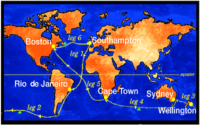
Leg 1 Southampton to Rio de Janeiro
Leg 2 Rio de Janeiro to Wellington
Leg 3 Wellington to Sydney
Leg 4 Sydney to Cape Town
Leg 5 Cape Town to Boston
Leg 6 Boston to Southampton
The table gives details about each
leg.
 =
Waypoint Marks =
Waypoint Marks
The yachts will sail through the Bay of Biscay and the Doldrums
to Rio de Janeiro, South America. After this stop-over, they will
round Cape Horn, encountering the winds and waves of the Roaring Forties as
they push towards the next
port of call, Wellington, New Zealand.
From here they will race to
Sydney for a short stop-over before battling across the Southern
Ocean
to Cape Town, South Africa.
From Cape Town the crews will sail along the South East Trades
through the Doldrums and across the Atlantic
Ocean to Boston, before an exhilarating sprint home to the UK.
A corridor has been created within which all yachts must sail, the Lisbon Corridor, where
competitors must sail east of a line between Berlenga Light at
39o 25'N, 9o 30'W and 38o 40
'N,9o 40'W. This corridor is 45 miles
long and about 4 days out of Southampton.
Waypoint Charlie at 52oS 120oW must be
left to port on the second leg, Waypoint Delta on the fourth leg at 47oS 72oE also
being left to port, and also Waypoint Alpha at 43oN
47oW. All three waypoints are
designed to reduce the risk of encountering ice in the southern ocean
and Labrador current.
Icebergs
Even in the southern summer, conditions
in the Southern Ocean will be freezing. Should the fleet venture much
further south than 50o, it will likely
find itself having to keep a lookout for icebergs and smaller
'growlers' which cannot be detected on radar. Icebergs which drift
south from the Arctic in the cold Labrador current may be seen again
off Newfoundland on the homeward leg. Waypoint Alpha is designed to
reduce the risk of ice encounters here. |
Cape
Horn
This great headland at the tip of South America - the
most legendary and feared nautical landmark of them all - lies at
56oS. Its reputation as a destroyer
of ships and men was established during the clippership days, when the
sailing ships would sometimes battle for weeks just to round the cape,
assailed by endless gales and mountainous seas, with sleet, snow and
hail driving in from the Antarctic. Prevailing winds are from the
west, as is the current.
 Download a video
about Cape Horn (2.5Mb) Download a video
about Cape Horn (2.5Mb) |
Cape of Good
Hope
Named by early Portuguese explorers looking for India,
this is the meeting point of the South Atlantic and the Indian Ocean.
It was originally called the Cape of Storms, with good reason. The
continental shelf is shallow, and when a south-westerly gale meets the
south-flowing Agulhas Current, giant seas can be kicked up. Winds are
unpredictable and gales can arrive from any direction, at any time.
|
Cape Leeuwin
The third of the great capes, Cape Leeuwin,
marks the south-western corner of Australia. At 35oS, there is nothing between it and the South
Pole except more of the world's most inhospitable sea, the Southern
Ocean.
|
|